“What the hell are you thinking?“ has settled into my mind as I started a morning workout. Twelve hundred miles seems like a lot when you’re not warmed up yet, I just have to rationalize it into manageable chunks. It’s only 200 workouts, it’s 4 Everglades Challenges back to back, it’ll be fun…. Oh shit. After 30 minutes I find a groove and by the end of the workout I feel entirely better about it. It’s simple math. The race must be completed within 30 days, the record is 19 so I must average at least 40 miles/day to stay in it and better than 63 to beat it. No days off, fifteen to twenty hours a day in my 18’ by 21” kayak to cover 1200 miles.
In 2010 I’d found an article about the Everglades Challenge (EC). A 300 mile race from St Pete FL to Key Largo put on by www.watertribe.org. To sign up you need a small boat, some money to buy a lot of gear with and a tribe name. I chose BustedRudder and there will be other names mentioned in this writing. It is an unsupported race, meaning you must pack what you need for the entire trip. There are 3 mandatory checkpoints you have to say Hi at, and water from a hose is available. You may purchase what you like on the way, and if some boater takes mercy and offers a cold beer that’s OK. Other than that you are on your own. Outside support is grounds for disqualification. There is a 100 mile section that traverses the Everglades National park where there are no facilities whatsoever, no cell and sketchy radio reception but it is far and away the best part of the race. I had entered 4 ECs and completed 3. For me, the first attempt was where I gained the experience I needed to complete a challenge.
Every other year the Ultimate Florida Challenge (UFC) is run, and there are 5 “Stages”:
- Stage 1 starts with the EC and finishes in Key Largo
- Stage 2 goes up the east coast to Sebastian Inlet
- Stage 3 completes the east coast at Ft Clinch
- Stage 4 heads west up the St Marys river to St George GA. The cart you have painstakingly designed and carried the whole way is how you portage your boat 40 miles to Fargo GA where you put in on the Suwannee River and go downstream to the Gulf of Mexico and south to Cedar Key.
- Stage 5 heads south to the finish / start.
There are 6 classes:
Class 1- Expedition kayaks and canoes, up to 1 meter sail (touring kayaks up to 18’)
Class 2- Racing Kayaks / canoes, no sail (surfskis)
Class 3- Sailing Kayaks and canoes (usually have outriggers and larger sails and leeboards)
Class 4- Monohull Sailboats and small craft (sail rowing or peddle drive)
Class 5- Multihull Sailboats (go fast cats)
Class 5- Hobie AI & TI
Class 6- Electric vessels, solar charging only
I’ve always been class 1. A kayak has some advantages. It forces minimalism, has dry storage fore and aft, and because of its slim profile can go nicely into the wind. I can carry a sail to take advantage of the wind and make great progress with no wind. Even loaded I can carry it past a rocky shore and be very stealthy when camping in unapproved locations. Stealth camping is easier than it sounds. In practice you arrive in the dead of night and depart before dawn leaving no trace. I’ve paddled a Necky Looksha III, a QCC 700X, an Epic 18X and for this event I bought a used KayakPro Marlin spent a lot of time making mods and adding a sail. The KayakPro is a carbon/kevlar epoxy cored race boat. At 36 pounds it is in the extreme lightweight area. This was cause for some concern. How would it deal with riding over downed trees on the St Marys, shoals on the Suwannee River or a fluking by a manatee? I was willing to make the assumption all would be well because what it has that no other racing kayak has is a bit of rocker and a tall cockpit. If you put a kayak on flat ground the bow and stern are either in contact with the ground or off the ground. If off the ground that is positive rocker and it affords better handling in a sea. Tampa Bay, Boca Grande, Whitewater Bay, Florida Bay were familiar to me and all give me butterflies just remembering prior crossings. In 1200 miles I would meet a lot of new water. The taller cockpit made the boat the driest I’ve ever had.
The UFC had never been on my radar. It meant too much time off of work, or too large a chunk of vacation time. I had quit my high stress high tech job nearly a year before the next UFC which is just the right amount of time. Aside from basic physical training the UFC requires a cart that can carry your boat 40 miles. It had to be light, and collapsible for storage under deck. I made several prototypes before settling on a design that let me use the same wheels for a tiny stern cradle for short portages like the 100 yards at Flamingo, the Ft Clinch ramp and the ¼ mile big shoals portage on the Suwannee river.
I scoured the course with Google Earth for possible camp spots and points of navigational confusion. A SPOT tracking device is required so I was able to view past competitors’ tracks and places they camped. I added nearly 300 additional waypoints to my EC set. Provisions of freeze dried meals, Hammer Perpetuem, electrolytes, dehydrated bananas/ mangos, batteries, spare lights, spare GPS, and clothes had to be divided into bins for DJ to deliver to staging points.
People ask me “how do you train for 1200 miles?” I asked a lot of people the same question. There were so many answers I quit worrying and continued with the same training for an EC. You may be tired at the end of an EC but by then your body has made the adjustments it needs for a long haul. The hands are already beginning to heal from the inevitable blisters and your butt is either good or bad. I had settled on a seat called the “Bumfortable” for several ECs and never had an issue. I had removed the original seat and tracks that the boat came with but retrofitted it so I could swap it out with the Bumfortable should I have issues at a later staging point. Aside from paddling 6-12 miles a day and continuing to enter into short races I focused on items to maintain my sanity. Several people had dropped out heading up the east coast, even past the halfway point. Some for dangerous weight loss, others from simply having had enough. I downloaded books on tape and tons of music for my small mp3 players and preloaded NPR stations into the FM radio presets. Friends have asked me how the hell you can sit in a boat all day long, to which I have honestly answered “It’s not just the day and you can’t believe how fast the sun travels across the sky”. I was counting on it.
See You On The Beach
Chief (Steve Isaac creator of WaterTribe) likes to say the hardest part of the challenge is getting to the beach and he is spot on. There is the boat, required gear, personal gear, food, hydration, navigation, lights, a plan and more plans for contingencies. It took me 6 months to prepare for my first EC in 2011 and I dropped out at Chokoloskee (CP2). I thought I was ready and prepared but I simply did not have the experience. Every challenge has helped me whittle down the gear to the bare essentials which equates to less weight and easier to find what you need when you need it. I have an Excel spreadsheet for packing my boat by location. Forward deck, forward hatch, cockpit, day hatch, aft hatch, aft deck. I will pack and repack the boat several times fine tuning for each challenge. Consistency of storage means no matter how bonkers you are from exhaustion you can find what you need even in the dark.
There are logistics in that people come from all over the country, you start and finish 300 miles apart so transportation is an issue. For me this year this was easy since I was starting and finishing in the same spot!
You need to be in condition with the right gear, the right boat and with enough experience to not drop out. Weather is a huge issue. The first EC I finished 2012 was also the year only 17 of 84 boats finished within the 8 day limit.
A common WaterTribe salutation is “See you on the beach”. It’s hopeful and sets a tone of anticipation. The day before the start is check-in, gear inspection and the skippers briefing at 4:00 PM. Then it’s your last normal meal and an attempt at a good night’s sleep. A hundred or so boats sit prepped on the beach that night, the competitors arrive in the dark for roll call and banter and the race starts promptly at first light.
This was all a familiar routine to me now. I remember my nervousness the morning of my first attempt, wondering if it was possible to make CP1 60 miles away the first day of a 300 mile race. Now I was looking at 1200.
“The stage is set, the exits barred and the makeup won’t come off” (“Carol” by Al Stewart)
Stage 1: Start to key Largo
It was a beautiful paddling day March 5. Sail up soon after the start, easy reaching through Sarasota Bay with no sign of big winds that can make Sarasota Bay a nightmare. As has happened in almost every EC I bumped into Jungle Jim who was sporting a new Flat Earth sail and wound up paddling with him. We passed KayakVagabond who remains a purist paddling class 1 without a sail. We were the first kayaks into CP1, got water, rigged for night and moved on. Crossing Charlotte Harbor at night is cause for angst and it’s good to be paddling with someone else. The first time I met Jungle Jim was EC 2012 at CP1. It was the last year that checkpoint was at Placida, a funky kayak rental shop with a decent landing, hot showers and a bunkhouse! CP1 seemed like a refugee camp that year with boats waiting for a weather window. I was holed up in the bunk house waiting and overheard SaltyFrog telling Jungle Jim the time to leave was in the next hour while the winds were moderate. I would not have guessed that 0300 was a good time to go, but I packed my stuff and as they left the cabin next door I got behind them and said “sounds like a nice plan do you mind if I join you two?” 2012 was an amazing EC. More of a survival school than a race.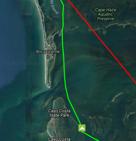
It’s 8 miles from CP1 to where Charlotte Harbor starts to open up. The wind always seems to freshen, and it works with the tide to make for a confused sea. Tonight was not one of the “bad” years and we crossed from Boca Grande to Cayo Costa without incident and camped at a nice spot on the south end of Punta Blanca Island KayakVagabond had shared with me. Not a bad first day, 80 miles down.
We made good progress Sunday down Pine Island sound, under the Sanibel Bridge and down the coast outside to Gordons pass. It was well past dark when we arrived at Gordons pass and we were taking great care to be lined up on the channel before entering. In 2011 I was rolled by a breaking wave in broad daylight here and I remain respectful of this inlet. A spotlight and blue lights came on. Florida fish and game wanted to know if we were OK and had we been fishing! Really? Do we look like were fishing?
Two hours later we were pitching camp on a sand bar across from Marco Island.
We paddled up the Marco River, around Goodland and out into the Gulf at the North end of the 10,000 island area. This is the point of the EC where it becomes magical. Civilization drops away, the gulf is clear of boats and you paddle by island after island some with nice beaches.
Unfortunately the wind changed to SE and began rising making it ugly outside in the Gulf of Mexico. We ducked in past Camp Lulu Key and made for West Pass Bay. It was a slog to CP2. Jim and I pulled the boats up with the others and pitched camp on a berm near the road.
It was still dark when I got up, packed my pad, bag and camp clothes. I went to stow the gear in the boat and the boat wasn’t there! Jim’s boat was there, the spot next to it where my boat had been was empty. I stood there dumbstruck with panic rising. Obviously the boat had drifted away but where? The options were endless and all bad. How stupid am I! What a rookie stunt! It was still too dark to see the bay. My wife DJ was asleep in the truck which didn’t stop me from waking her with “I have a disaster”. I got her kayak down just as the bay was 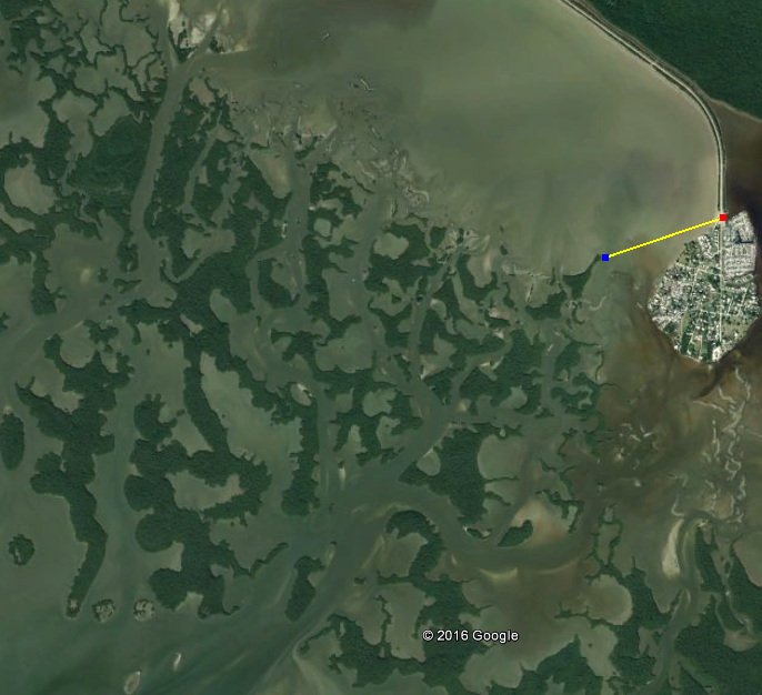 becoming visible. By now I’d drawn a small crowd of Tribers watching the show, one of which was Toby “Whitecaps” who had a pair of binoculars and said “there it is!” It had drifted less than a mile straight across and was bumped up against the mangroves. What luck! Had it been 75’ to the east it would have cleared the point and gone several miles into the shallows with a falling tide. If the wind were less it could have headed for the gulf. I retrieved the boat with DJs boat graciously accepting the much deserved ridicule on return. There is no greater sin than not properly securing your craft in an event like this. I had made the mistake of assuming safety in numbers dragging up adjacent other boats. This debacle factored into my dreams and nightmares for weeks to come
We chose the inside route from Chokoloski, the “wilderness waterway” because of the weather. Some people love the WW, I don’t get it. For me it is not nearly as interesting as the coast, and it adds miles. We teamed up with Seiche and HammerStroke and were underway. Around midnight we made the Broad river campsite. Someone was already there so the five of us setup in a cloud of mosquitoes in the opening behind. We were in our tents and going to sleep when Jim moans “Oh shit”. The strange gurgling sound I’d heard was now explained. Water was weeping straight up through the porous ground on the rising tide and we had 3 inches of water under our tents! We had to cram 5 tents into the last remaining dry land. I wound up next to HammerStroke who begins snoring immediately and only gets worse with time. Ughh. If you like difficult landings, mosquitoes, wet and mud this is the spot for you. Broad river makes the Graveyard campsite look good.
The next day was no better. Jim and I departed early and he decided he wanted to try the Nightmare, an aptly named shortcut between Broad River and Shark River no wider than a kayak paddle. I really should have just gone out Broad River as planned but Jim was insistent. “Come on Bob, It’ll be fun!” It was near low on a falling tide which did not bode well. We struggled through snag after snag until we wound up looking at a creek without enough water to float a dixie cup. It would be 3 hours before any possibility of floating so we gave it up and resumed down the Broad River to the gulf having wasted valuable time. South down the coast we stopped at Graveyard for a quick break as it was the last land and 28 miles to Flamingo. Graveyard holds a special spot in my heart. EC2012, the survival year I camped here with SaltyFrog and Jungle Jim at 0200. It was about halfway between CP2 and Key largo, in the absolute middle of nowhere and I was ecstatic to be there. It meant I was going to complete the EC, there is no point in turning back.
Our timing was good entering Whitewater Bay being able to ride the tide up Joe River. The wind was relentless, just like 2012, paddling in the wind shade of mangrove when possible and slogging it out when not. It was nice to duck into the Buttonwood canal, but as usual Coot Bay was frothing. The water here is brackish and very tanic. Somehow the chemistry makes the water appear to have been spiked with dish soap the wind driven chop is constantly breaking and white. In Coot Bay it seems the wind always blows directly from where you want to go. I wanted to test the theory that the shortest distance is not necessarily a straight line. I hugged the shore which according to Google Earth is 2.12 miles and Jim went straight (1.65 miles). I beat him to the entrance. Trees will absorb some of the wind, and the surface current a wind generates is reduced next to shore. We arrived at Flamingo CP3 at dusk.
The forecast for Florida Bay sucked for the next 3 days. There was no option except to leave at first light. I’d taken Crocodile Drag 3 times and never Twisty Mile but local knowledge and the wind direction made twisty sound better. Less fetch once we were in deeper water to the east and more islands to get shaded by. We were off at 0600 and met up with Spiritwalker a short time later.
The water from Flamingo to the exit of Twisty Mile is shallow. The only navigable waters are the narrow channels cut and maintained by the fishing boats traversing the bay so no significant swell can develop. The headwind was significant so we started taking turns drafting each other like bicyclists do.
That all changed when we broke out into deeper water past Twisty Mile. It was a slog to Russel Key and I began to notice a strange sloshing in the boat. Crap! I’d left the day hatch open and it was half full of water from the waves we were crashing through. All I could do was close it and hope for the best. It was impossible to sponge it out in the current conditions so I had to fret over 16 pounds of water sloshing back and forth as the boat pitched up and down through the swell. I was happy to get a break at Russel Key to bail out.
As predicted the wind kept building all day. The 3 of us remained in loose formation on the way to Manatee Keys. I’d never seen swells like this in FL Bay before. The waves were so close together I’d lean back trying to get the bow to go over a wave, once over the boat would fall into the trough and the next wave was on me and I’d stuff into the face of that one. That cycle effectively stalled forward momentum. It seemed our average speed was between 2 and 3 MPH. It was going to be a much longer day than we had hoped. At the tip of Manatee Key we found a tiny cove the three of us could fit in to rest and snack. I looked up over the edge and it looked like a small clearing of salt crusted “land” that might be campable in a pinch. I filed that tidbit away under “any port in a storm”.
The slog to Bottle Key was the worst I’d ever experienced in Florida Bay. The boat was crashing so violently in the swell I was worried about structural integrity of the hull-deck seam and the bulkheads.

I had added a day hatch to my Kayak Pro which meant adding a third bulkhead 18” aft of the bulkhead behind the cockpit. It was a weird sound. The stern was slamming down much harder than the bow. I would have loved to see what was happening but to turn my head that far around would have resulted in a capsize so I decided what I was feeling was the stern plunging underwater and the water filling the void it left.
We found a small beach to land at Bottle Key and rested 30 minutes while looking at weather. Every source was calling for 20-25 knots. We were only 7 miles from Key Largo but we decided to hug the shallows east before turning northeast once in the shade of the keys. Nearly 3 hours later we landed at 1930 hours. 13.5 hours to go 30 miles. It was a thoroughly shitty day but there was cold beer and a warm DJ!
Stage 2 Key Largo to Sebastian
Where the EC had become a familiar course to me everything was now net new starting with Biscayne Bay. I had spent a copious amount of time fretting about it on Google Earth, studying tracks of prior racers on the Watertribe site and trying to identify possible stealth camp sites. I bugged prior competitors who offered some sobering info: “Just watch out for the National Park Service they use FLIR (forward looking infrared)”. Great! What about Ragged Key? It looks like a good spot. “It’s called ragged key because of the coral that will shred your boat”. “Watch the Safety Valve, you can wind up offshore with an outgoing tide”.
Biscayne Bay is a large body of water 50 miles long and 10 mile wide beginning north of the keys and ending at Miami. Here starts the 60 mile “Concrete Canyon” referring to the stretch of unbridled wealth stretching from Miami to Palm Beach on the ICW (intercostal waterway). This stretch has no natural shoreline. Both sides of the very narrow waterway are concrete or metal bulkheads.
The choice for Biscayne Bay is east side or west side depending on wind direction and I had yet to decide as of departure. Sharkchow, the record holder for the UFC was in Key Largo to act as master of ceremonies for the EC awards and was up early and honored me with a chart briefing. Stay east, watch out for the safety valve, stay east of the proper channel and be ready for the turning basin.
It was strange to leave Key Largo. Several times before it had been party time, drinking cold beer and cheering arrivals from the EC. This time I was not part of this scene. I was only ¼ the way through my race and I’d better get going before I started hearing the “sirens”.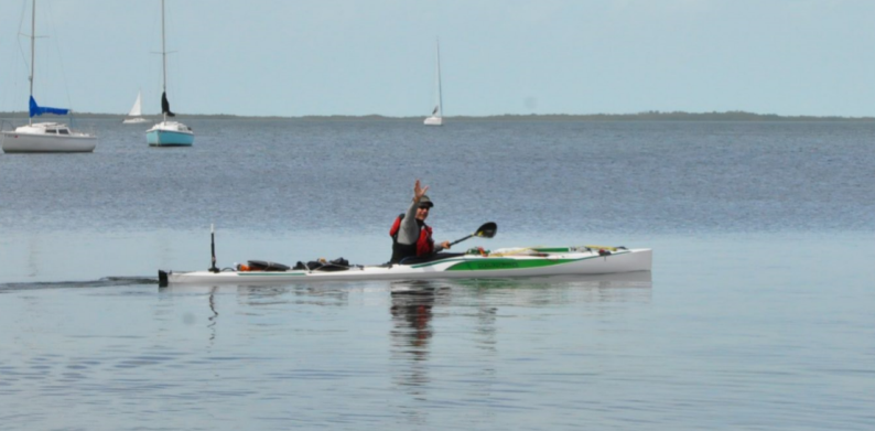
People asking me EC advice were always told to avoid staying at checkpoints. They tend to have hot showers, fire pits, cold beer and other niceties that will strive to delay you.
I had a number of potential sites to make that evening, the only legal ones were Main Key and Card Pt suggested by Salty Frog only 10 & 15 miles out. The wind was such that I could paddle sail and stay somewhat close to the east side which eliminated using either of those spots without violating rule #1 “Never give up the windward advantage”, plus the day was young. Everything was new to me from now on. The familiarity of the EC gave way to the constant wondering of what kind of sites I might find and when. In my Google Earth studies everything was mangrove up until the area of Boca Chita and as the day faded it was clear I would be making camp in the dark in new turf.
It was beautiful water and the stars were out. Eventually the Boca Chita light came into view. I had a waypoint where others had stealth camped, still an hour away when I picked up the glint of white beach only a mile or so away. I diverted then saw a pier and landed just north of it. I dragged above the high water line and set camp. It was an easy 33 mile day and was in my bag by 2300 in a perfect position to finish off Biscayne Bay.
I was up at 0330 and on the water at 0400. I wanted to hit the Safety Valve at first light and Miami before the height of traffic. It was easy paddling and the blinking channel lights were visible to the west staying east of the channel per SharkChows advice . The glow of Miami made for an obvious destination. As dawn came, the water was perfectly clear and the intermittent shallows and deeper ruts of the Safety Valve became evident. By chance it was slack low so the rip out to sea that others had cautioned were nonexistent. It became lumpier as the wind and depth increased. As Stiltsville came into view in the distance and I knew the water would flatten as they were in shallow water. At the entrance to the Channel I stopped at a park on Rickenbacker causeway to use the facilities and fill some water bladders. When I returned to my boat there were several police cars and officers on the beach not 20 feet from my boat. I was happy they had no interest in me, their attention was focused on a guy coming out of the water stark naked who was immediately handcuffed and wrapped in a blanket. Welcome to Miami!
Miami and the concrete canyon is a study in how not to treat the marine environment. Wave reflection occurs when there are no shores to absorb the energy of boat or wind driven waves. The turning basin in the port of Miami is such an area where all the various boat waves are reflected back into the channel creating what is best described as “popcorn” in which waves from all directions collide with each other and go straight up. A kayak will be lifted straight up a foot or two then dropped immediately. It can make for tough going as there is no consistency to the chop. Once through the area things settled down as speed limits are strictly enforced. The other downside to bulkheads is the elimination of marine life. Banks with grasses and tidal transitions support a variety of beneficial marine fauna and flora. The canyon seemed devoid of marine life, just many miles of dark, oil streaked dead water and thousands of vacation homes for the idle rich and their status crafts.
 My despair was broken by the sight of a boat ahead that could only be WaterTribe. It was JarHead, and as I came alongside he smiled and said “Hi BustedRudder, would you like a cold beer?” “Holy shit! You have a cooler in there?” We enjoyed a couple of Ybor City Golds…. A slice of heaven in a strange place. Jarhead complained of his VHF going out and I groused about my spot batteries dying before Sebastian the next staging area. We said goodbyes and as I paddled away he hollered that he had spare lithium AAA batteries. Going back I realized he could use my radio more than I, he needed to open bridges. He begrudgingly accepted the radio on the logic that I had not used it once and parted again.
I was in high spirits after seeing JarHead and decided to get to work. Put on the headphones and started paddling. I wanted out of the canyon, and didn’t stop until 0200 when I checked out a site in Lake Worth that Mosquito Magnet had stayed on his UFC. It was at the base of a bridge intersecting A1A so I’d named the waypoint “MM troll bridge”. On Google Earth it looked iffy, exposed and potentially illegal. As I neared I saw it had a stand of scrub trees so I thought maybe this would work. I beached and started looking with my headlamp. Cardboard, trash, then a foot and another foot from a different direction. Oh shit a homeless camp! I was gone pronto looking for the next spot north on Hunters Island I’d saved that seemed promising in GE. I found it, and it had a perfect grassy level spot facing the breeze just wide enough for a tent. No mosquitoes, no vagabonds! A perfect spot after an 83 mile day! Instantly to sleep after a dehydrated Beef Stroganoff and Capt Morgan chaser.
Off before first light paddling north. One day blends to the next and the scenery had become insanely repetitious through West Palm, Riviera, Jupiter and Hobe Sound. The wind built all day and I enjoyed sailing for a good part of it. I crossed the St Lucie inlet and took a break at Sewalls point. I’d lost the 2nd of 3 GPS units this day to moisture and wanted to see if letting the two failed units bake in the sun with the battery compartments open and skyward would help. After 35 minutes I tried putting batteries in them but they were both toast. My last GPS was now in a waterproof bag only to be turned on when necessary so as to keep the batteries alive until it was safe to change them. I decided to reef my sail before leaving and headed for the Sewall causeway bridge directly downwind. Thus began a very memorable ride.
If you stand on a shore looking out on water with the wind in your face you see the water as bad as it can be. If you stand on the same shore with the wind on your back the water seems quite nice; but when you leave that shore and travel with the wind, the greater the distance the greater the effect the wind has on the water (fetch).
By the time I got to the Stewart causeway, aiming for the wide span of the ICW I no longer needed to paddle. I was taking strokes but only to feel like I was in control. I cleared the bridge and realized the shit I was in for. The next span was 3.5 miles off and as the fetch increased the swell increased. I began surfing swells without paddling at all, bracing and dragging to help maintain straight downwind then down swell. The ass end would rise up and the boat would tear down the swell and stuff into the next swell. I could feel the deceleration as the boat disappeared into the back of the next wave and water covered my skirt with only the sail above the water. That cycle repeated again and again. I was happy I’d installed the deeper rudder intended for double kayaks for use with a sail. Broaching in these conditions would be bad. I considered getting the sail down but I would have to let it weathercock and luff then use two hands to get it stowed. One hand off the paddle would be bad enough let alone two. I decided the safest thing to do was to simply ride it out. If I broached perhaps then attempt to douse but I might not be upright then anyway. It should have been fun; but that section of the ICW is 2 miles wide, it was getting late in the afternoon, and I wanted some calmer water. Ass end up, slide down and stuff while using rudder and paddle to keep exactly 90 degrees to the swell while trying to sneak a bit east to keep lined up on the ICW of the Jensen Beach span. Several sport fishermen running home had passed me giving as much space as they could; their wakes intersected the following seas compounding the already tenuous conditions. I was a quarter mile from the span when I could hear another sport fisherman approaching. My 8 mph pace and his would have him passing me close to the span right next to me as we both vied for the same ICW span. I could only speak out loud with no one to hear: “please don’t do this to me”. I suppose from where he sat he could see my situation. I heard his superchargers spool down; he was slowing to let me clear the span first! Five minutes later I was clear of the bridge and he took off. I could not take a hand off to wave, but I did open my fingers as a gesture. He just looked at me with that familiar disdain. He didn’t approve but I am grateful nonetheless.
 It began to rain which helped calm the water, the cockpit was sloshing and I had about an hour and a half of light with no good campsite for hours more. I was over this day and wanted off the water. There were numerous docks on the west side of the ICW in Jensen Beach, some with what looked like campable beaches. I simply pointed towards the best looking beach and went to it.
The houses that own the beaches are on the other side of a road paralleling the shore. There was an elderly woman in the front of the house to the south of where I’d landed. I apologized for my appearance and asked if she knew the people next door and if she thought they would mind if I crashed on their beach, I’d be gone before light. She didn’t think that a problem and offered her beach as well. Having established a level of permission I started working the boat. Not 10 minutes later a guy showed up and asked if I needed anything. He offered a room and shower! I opted to pitch tent on the dock and accepted his offer of a shower after I cooked a meal. The shower was delightful and I joined Jim and Mary for a glass of wine and discussion. What a perfect ending to the day.
 I slept in till first light. I had 41 miles to Sebastian where DJ would be with supplies. The congested narrow feel of the Canyon was now behind me. The ICW was wide and traffic was much reduced with a manageable breeze.
Hands are a big deal for a paddler. If you get deep blisters you are in trouble. Typically you will know in 2-3 days which means when you finish an EC you are past the worst of it. I never wear gloves. Gloves keep your hands wet and waterlogged hands are prone to slough off any skin that has a blister. For the first few days of a long event I use Aquaphor (diaper rash cream) on my butt, pits and hands to keep waterlogging down. If it’s not a rough day and you are paddling well it is possible to have dry hands by keeping a loose grip on the recovery of each stroke. With about 80K strokes in a 17 hour day it’s worth the effort. By now I was amazed at my hands. They were claws that had grown around the paddle shaft such that any part of my hand in contact was like leather pads. They no longer opened all the way and the creases on my finger joints and palms marked where one pad left off and the next took up place. One less thing to worry about.
It was a nice day to Sebastian and as I approached I saw a windsurfer tearing up the water. Getting closer I recognized the sail! That’s DJ! How fucking cool is this?? I was so happy to see her having fun while chasing my butt around the state. I spent 3 hours there drying clothes, changing batteries, cleaning and organizing hatches while taking breaks to sit in a beach chair eating the fast food DJ brought. It is impossible to consume too many calories in an event like this. I was losing weight but not enough to be concerned yet and devoured 2 big macs and took a third as desert for later.
Stage 3: Sebastian to Ft Clinch
I left Sebastian around 1600 without a specific plan except to keep moving. There are numerous spoil islands in the area and as I was losing light I saw one that seemed to have a nice spot to land. I beached and found a placard on a tree that identified the spoil as “Maintained by the Malabar yacht club. Pack in Pack out, Enjoy”. Later I found it was “BC38” part of the Spoil Islands project http://spoilislandproject.org/ which gets local people involved in maintaining public use spoils created by the dredging of the ICW. I had a picnic bench and a bed of Australian pine straw to camp on. What a treat to cook and eat on a table and then to have a junk food desert! A great night’s sleep!
Up and gone in the dark. I so enjoy being on the water, moving and warmed up before the first hint of dawn. The stars slowly fade and yield to the broader view of the horizon and land. This is a nice section of ICW. Lightly populated with a number of seasoned spoils, some built up 25 feet from dredge operations. Most spoils have at best scrub vegetation on them but these had large mature Australian Pines and small cedar. The NW wind had me hugging the west side of the ICW most of the day. I could sail close hauled sometimes, sometimes having to stow the sail on deck.
The day was counted in bridges linking the mainland to the barrier islands of Melbourne, Rockledge, Cocoa and eventually Titusville. I was approaching home turf as the sun set and several hours after dark I approached Haulover Canal. I’d been relatively bug free since Key Largo but was now pestered by mosquitoes and flies. Not a big surprise, Haulover Canal does end in mosquito lagoon! I was now 55 miles into the day and wondering where I’d wind up. I had a depressing lack of camp spots in my GPS. I guess in preparation I assumed this was my backyard and there were lot’s of spots? Wrong. Most of the spots were a short hike towards the inside of the spoils and impossible to see from the water in the dark. I knew Ponce inlet had sandy spots near disappearing island and that was my closest confirmed stop in 25 more miles.
It was shrimping season and the ICW in Oakhill was full of small boats, all of them surrounded by glowing water of different colors depending on what LED color the shrimpers thought best that night. Some were anchored others moving it was an effort to maintain distance.
Finally clearing the bridges of New Smyrna I was in Ponce Inlet paddling towards the same spot ArdieO had used in 2013? I landed, got out to stretch, hit my spot and looked about. There was a breeze from the ocean I can only describe as heavy and wet. It was apparent I would have a miserable wet night here. Shit, I’m only 4 or 5 miles from a friend’s house on the ICW. I decided to stealth camp on his lawn and arrived there about 0500. My biggest day yet at 85 miles.
During the UFC the dreams started after my lost boat debacle at Chokoloskee. Since then I always had a view of the boat from my tent. No exceptions. It was always tied off to a something secure or the tent itself if nothing else was available. At least once a night I’d wake in a dream state and look out the tent to check that the boat was there. Indeed it was but there would be water between the tent and boat or we would both be afloat in shallow water. That would make me fret about how to properly navigate from inside a floating tent without losing sight of the boat which of course was never tied off in the dreams. With the tent afloat I could never understand why my crocs just outside the tent stayed in place. This went on day after day with subtle variances thrown in. If the wind was blowing that would add extra fret about keeping the tent, crocs and boat in view lest we get separated.
I was off to a late start and progress through the south Daytona Beach area was slow; a persistent headwind negated a sail. Only an hour or so into the day I was paddling the west side of the channel trying to stay out of the chop and heard faint shouting from my 10 o’clock. It persisted so I looked harder and saw someone waving arms. OK I guess I’ll divert. It wasn’t long until I realized it was CWolfe, my doctor and paddling bud who had talked me into the UFC and who had earlier in the year flown down for a Cedar Key practice run. Charles had bought a new boat for the UFC but it was delivered late in the training cycle. He completed his cart and seat at my house 2 days before the start. It was rough going for him and he wound up dropping out in Key Largo after equipment issues and an awful Florida bay crossing.
Having time on his hands he was touring a bit of Florida with his family and took the time to track me down to give me a huge cup of ice-cream caloric medication. We chatted for a while and he gave me a spare GPS. Tribers can offer aid to fellow Tribers within the rules. It was good to see him! It was a fine boost of morale.
Once clear of Daytona and Ormond the ICW is narrow but not busy and the west side is free of development being mostly marsh with occasional beaches. It was easy paddling past in familiar water that DJ had traversed multiple times in a sailboat.
Anytime I’m on or near water albeit crossing a bridge, in a power boat, in a kayak or Google Earth I’m constantly evaluating camp-ability. It’s simply a habit. Do I have a known good spot ahead or is it a Google Earth hopeful? What is it looking like right now and what will it look like further along? I had no confirmed sites ahead, and only boat ramps as possibles. I started looking and just before dark found a spot. It was a spoil, the top of which was littered with nasty chunks of rock or conglomerate from dredging. Tides and boat wakes had carved out a hard sand shelf down from that which I groomed into a flat exactly wide enough for the tent with a palm frond stem. The tide had just passed high so I wasn’t worried about that, I would be gone long before the next high. This was a disappointing day at just less than 30 miles. Sleep deprivation is a debt that is always collected.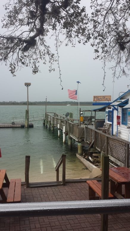
It seemed the northward paddle would never end. I paddled through Marineland then St Augustine and the silly pirate ship show they sell to tourists. Past St Augustine it starts to rain and I found Mikes’ Place. I pulled up on the beach and had a burger in the bar area while charging electronics and drying out.
I had marked 2 waypoints in my GPS where prior UFC competitors had camped then dropped out. The last of these I would make today. Someone was more than half way through and had lost hope.
Chief talks specifically to dropping out in the skippers meeting every year. “You can get discouraged, cold, scared, and overwhelmed. Dropping out may seem the prudent thing at the time. Don’t. Have a hot meal, sleep on it. You may see a way tomorrow”. I’m ad-libbing here but that’s the message and it’s sound advice. There is no UFC specific speech but I’d add loneliness and boredom to the list. I had not seen another competitor in almost a week and would not until the finish. DJ was keeping on top of a Facebook thread and though I was rarely competent to make a post the encouraging comments were most welcome. It could be a personality defect but when the paddling is straightforward I’m able to disconnect from that task and zone out. Watching the moon each night I once spent the better part of a day trying to visualize the earth and moon in their orbits about the sun. As I’ve said before you would be amazed how quickly the sun moves across the sky. It helps to have your mind busy.
I was approaching what I nicknamed the bridge of despair at 2230 when I hear someone yelling “Dad!” It was my daughter Katie who lives in Jacksonville and she is in the middle of the bridge waving her arms like a lunatic. I setup camp on the west side at the Nocatee kayak launch and Katie has a chair, beer and junk food with her! OK, this might be breaking rules but this is unexpected and too good an offer to refuse. Plus it is another invaluable boost in morale when I need one. It was a worknight for both Katie and I so she took leave and I retired to my tent. Being able to see the underside of the bridge from my tent added a Close Encounters of the Third Kind dimension to my dreams that night.
I’m now losing the incessant civilization once north of JAX and approaching the St Johns River. I was very happy to be crossing in daylight! The dredging operations there are 24-7 to keep Mayport Naval Station open and the buoys and booms would have been very dangerous at night. Add an outgoing tide to the rivers normal outflow and I was really working but barely making progress. They had one of their super stealth ships in dry-dock and parts of it were cloaked in tarps. Not sure if that was EPA tarping for sandblasting or “you don’t need to see these private parts” but the message was clear to stand clear having to struggle past 2 well-armed boats with expressionless crew staring at me. It took an hour to cover the last mile around the dry-docks and under the Pine Island bridge. Things settled down and I was happy to see nothing but marsh and beaches except they weren’t beaches. In my Google Earth planning I’d marked some of these “beaches” as possible campsites. Local Indians harvested oysters for centuries and piled them for settlements and lookouts called “middens”. While they seemed to be tide related, I could not imagine how they could be 5 feet above the highest tides! More headwind and gray skies made for a long day to Ft Clinch which I arrive at 1730.
RidgeRunner (Doug Cameron) was the checkpoint captain and kindly watched my boat allowing DJ and I go out for a bite. This was the first time I had been in a car in 13 days and I was amazed how fast we were going. It seemed like DJ was a crazy person. I’d been going 5mph so long 55 seemed like lunacy. We had pizza wine and beer and continued the party in the parking lot behaving like teenagers before we retired to our separate abodes. Me in my tent and her in the truck. Besides the boat, the pavilion roof structure at Ft Clinch was in view that night and further enforced the Close Encounters aspect of a spaceship hovering over us that started in Nocatee. I use “us” intentionally. Like “Wilson” in Castaway the boat was now my most trusted companion.
Stage 4 Ft Clinch to Cedar Key
In the UFC you head south till you can head east then head north till there is a river to go west, when that river peters out walk your boat (portage) 40 miles to the next river. Take that last river to the gulf and finally turn south again to the finish. The north part, 415 or so miles was finally behind me. You don’t leave Ft Clinch without consulting a tide chart, and it said I had some time to kill before catching the incoming tide. I paddled across to the city of St Mary’s to watch the incoming tide start. The trick is not to leave too early as you can paddle ahead of the tide. The last station on the St Marys they bother registering a tidal difference is 27 miles upstream of St Mary’s. It seemed that about 2 hours after low was the time to leave so I had an hour to kill. I was hanging out at the ramp of the local kayak rental when I heard someone say “Bob?” I turned to see Brian Houston and his wife who were vacationing from SW Florida. Brian is the Southeast Epic Kayak rep, an expert kayaker and great guy. It was good to see a familiar face, and we chatted about the race as he examined my KayakPro kayak with disdain. I jokingly reminded him yet again that if Epic were to make an expedition kayak with a real rudder I’d paddle it. We said goodbye and I was off riding a 2 mph flood. I had added waypoints for potential take outs and campsites but never created a route which would have given me an idea of progress. The best I could do was put the waypoint for the St George takeout in the GPS and watch it get closer then get further when the maddeningly winding river had me going away from my destination. SharkChow wrote of being shot at on the St Marys River in his book “Without A Paddle”. Indeed I heard gunfire a few times ahead which usually ended as I approached then resumed so things are getting better I suppose. Two very drunk young men challenged me as to whether I was a Yankee and ignoring the question seemed to violate a redneck rule. I was pleased there wasn’t a boat in sight for them to utilize as their verbal tirade could have become physical. If you ever wondered where all the Confederate flags went after they fell out of favor, rest assured they are all safe and sound on the Georgia side of the St Marys River. It became nauseating to see hovels and shacks adorned with the flag and tons of concrete refuse, appliances dumped on the river banks in a futile attempt to stop the rivers normal movement of banks. Late that first night looking for a campsite I saw what looked like a flat area up a bank. I stopped to check and found myself in the mother of all Confederate flag sanctuaries. Not a place to be found stealth camping but I did leave my opinion about the cause in the fire pit. At 0200 I found a nice sandy area to beach. It too was a local spot but no permanent structure except the obligatory redneck porta potty. A 5 gallon bucket rimmed with fake fur and no bottom. I camped as far from that as possible and was gone long before the owner might arrive.
Up and at it before light, it was nice paddling, but the river was now against me until St George. The last 5 miles of the St Marys river became narrow, faster moving and full of snags. I was ecstatic to be done with the St Marys when I arrived at the St George takeout at 1400. Now began the infamous portage. The bearings in the wheels that served me well with the stern dolly were rusted solid. I carried spare bearings so changed them out and assembled the cart. Once the boat was secured in the cart I began moving gear around to balance the load and dragged up to the road. I had wondered what this moment would feel like many times…. the total absurdity of walking down a road 40 miles with a kayak in tow. Here I was and I still didn’t know what to make of it so off I went. Four hours later I had to change into warmer clothes as the afternoon gave way to dusk. Nighttime brought a new dynamic to walking the kayak. I was on the right side of the road and was unsure of cars passing me so decided to change to the left at first sign of lights then return to the right after they passed. This was working well until blue lights came up on me from behind. I was actually being pulled over by Georgia State Police! “Is there a problem officer?” “I had a report of someone dressed in black walking down the middle of the highway”. I was wearing my headlamp which I switched off so as not to blind the officer and the swell sternlight that Jungle Jim loaned me in Key Largo was illuminating the area. The officer scanned the scene and said “well it looks to me like you are pretty well lit up”. I offered to wear my PFD which had a number of reflective patches on it and that seemed to satisfy him. He drove off saying to have a nice evening. I thought it a little odd he didn’t ask what I was doing, he must pull over kayaks all the time. My feet were beginning to feel like hot spots were developing and I was tired. I’d marked a number of potential camp sites along the road in a prior scouting trip and the closest ahead was 10 miles further than I wanted to go. I began scanning the sides with my headlamp for a campable spot and in an hour found a turnoff with a locked gate I could get under with the boat and get far enough to the side of the road that if a truck came in either direction I would not obstruct or be run over. This was the coldest night of the trip, down into the high 30s. Wools socks and my bag inside a SOL emergency bivy kept me warm enough to get some decent sleep. Since the lost boat episode in Chokoloskee I never had good slept unless the boat was in view from my tent and securely tied to a tree or the tent. It didn’t seem necessary to tie the boat off on dry land. I didn’t and sure enough I was punished with dreams of the tent and boat afloat and drifting apart. Wilson!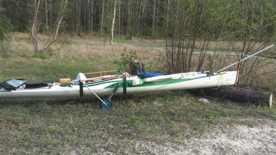
I was up at twilight and on the road. No need to choke down Hammer Perpetuem or some other too familiar food, I only had about an hour’s walk to Lacy’s Kountry Store and I knew from prior reconnaissance they would have the grill going. I parked the boat safely off the road and ordered 2 of their breakfast creations, got hot coffee and wandered the aisle looking for high calorie snacks and bottled water. They have a picnic table outside which I shared with a couple of locals who left shortly after I arrive
d. A week ago I might have been concerned that I smelled bad or looked a fright but I was way past that now. Looking like a “walker” was my station in life now. My money seemed to spend the same and I used some more to get a third wonderful hot breakfast sandwich. I thanked them for being there and was off. 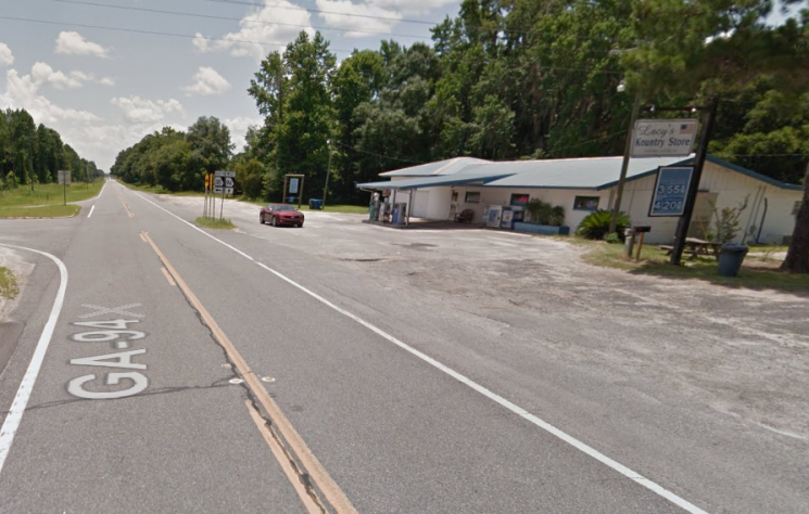 Only 25 miles to Fargo! The furthest I ever walked in my life was the 15 miles I did yesterday. To my knowledge no one had ever dropped out during the portage so I figured all was well. Besides a cart failure, being flattened by a truck or a foot delamination what could go wrong? A couple of hours later Chief pulls over in his new motor-home to say hi and offers me sugar and caffeine (a Coke) which I gladly accept. I lay on the ground while chatting about yesterday and the police episode. “Well that’s your first mistake! Walk on the left. If you see a truck coming and it doesn’t move to the other lane get off the road!” It was good advice. I never had to look behind. The truckers were as accommodating as they could be but with oncoming traffic they had to maintain their lane. Chief took off and the miles ticked off soooo slowly. I was satisfied the cart would make it. The wheels were a bit small and worried me when hitting holes, or crossing railroad tracks. Less than half of the 40 miles of road has actual paved shoulder so exiting the road for the dirt was problematic with the narrow short wheels. The larger problem was my feet and legs. I stopped twice to rotate socks being certain I was about to erupt in huge blisters. My soles felt hot, looked red and hurt with every step but the skin was still attached so I tried to stop worrying about it. The Watertribe forums joke about the last 5 miles being the worst. It’s not a joke. DJ had scored the last room at the Gator Motel and I arrived there before dark. The owner was there to greet me and assured me it was fine to park my kayak right in front as if most of his guests do just that. I was simply elated the portage was over! I sat in a chair with my feet elevated on the bed for awhile stretching my legs then went across the street to the only convenience store in town and bought a six pack of beer and a couple cans of Hormel Chili and started a party. I called DJ to thank her for scoring the room, trying to relay the sensation of my feet and legs and the joy of having the walk behind me. Before the store closed I made another trip for ice cream and went to sleep a very happy guy.
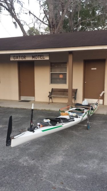
On the way to the Gator I had passed the Swannee River Café. The sign said open at 0600. My boat was parked out front at 0555 and they let me in 3 minutes early. Their buffet was chock full of essential calories and having satiated myself, was at the put-in shortly. In the dark I disassembled the cart and moved the wheels to the stern dolly I would need at Big Shoals, then rearranged gear that had been moved for weight and balance. Once again, I was on the water and heading downstream for a change.
I had done this section of the Suwannee 3 times in the Suwannee River Challenge which ends 60 miles downstream at High Springs. I was dismayed to see the water at least 5 feet lower than any of the challenges. This did not bode well for speed, the river was not moving as fast and there will be multiple shoals to deal with. I had hoped to be past the Big Shoals portage early but did not arrive till 1730. I pushed the boat up to the trail and attached the stern dolly and walked the few hundred yards to the camp area where the portage trail heads down to the river. There were a number of tents and who I assumed was the leader greeted me and asked if I could use a hand. In Watertribe terms, jackpot! Assistance if offered, not solicited is OK. There were a number of large kids at hand and they helped me down the slippery trail. Just as I had done in October I took a gainer and at the same spot. I was very happy to have one of them there to catch the boat. I thanked them profusely and got my now muddy self into the boat. Next up would be Little Shoals which is usually just a nice fast part of the river. As it came into view my stomach knotted. There was no clean way through, I just had to pick a spot that looked best and go. I picked poorly. I heard a sickening grinding then cracking sound as the boat ground to a halt in the middle of the river. I used my hands to push my weight up off the rocks and worked the boat just a foot or two until I floated and resumed. Not good. I had no idea what the bottom looked like or if I was holed. I sponged the cockpit out and saw no sign of water coming in, and then reached into the day hatch which was also dry. I’m 185 the boat is 38 lbs. If there were a hole it would likely be near me so I decided to wait till camp to check. It was pushing dark as I neared White Springs, and I was not interested in navigating shoals in the dark. I could hear them on approach but didn’t have a good visual on where to go until on top of them. After a couple of these I came to Stephen Foster Stare Park and beached at what turned out to be a perfectly beautiful primitive site. Someone even left a bit of wood in the pit which I used while I set tent on the bluff ensuring a view of the boat carefully tied off to a tree.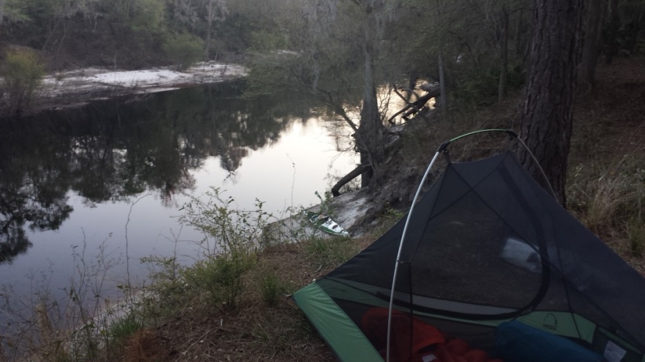 Up in the dark and off just one small shoal to get by and after that the day was just another blur of river. I usually like the Suwannee but with low water levels it felt more like a ditch with high walls and trees that blocked the sun for most of the day. It also had the annoying habit of funneling the wind exactly down the river even though the true direction was up to 45 degrees off the river direction. I was downstream, albeit a slow current but the headwind seemed to cancel that out. The only treat I had this day was a sturgeon. You hear them all night long broaching the water and slapping down. People in fast moving boats have been killed by them jumping into their path they are that large. I was by chance looking at the exact spot where one exited the water, twisting in the air and slapped down on his side! They are big! The day before I was treated to what looked like dogs in the water but upon getting closer realized it was two deer crossing the river. If I wasn’t on my self-imposed death march I might have more to say about the beauty of the river. It just got to the point where I had seen enough. It’s like the Wilderness Waterway between Everglades City and Flamingo. People gush about the beauty of 100 miles of wilderness and the week to ten days it takes them to do it. Really? How many fucking mangroves do you need to see until you get the idea?
I had been scanning the bank with my headlamp looking for a break flat spot to sleep on and found it at 2300. I went to sleep thinking this thing is almost done. Tomorrow, the 24th, I had a room waiting at the Suwannee Gables motel, my first hotel room since Key largo 12 days ago. From there Cedar Key then 2 or 3 days to the finish. The math was against me to beat the class 1 record set by SharkChow in 2006. What a year that was! Three competitors finished within 10 hours of each other after 19 days! I had been alone since overtaking JarHead in Ft Lauderdale. Two go fast catamarans had just finished, 2 had dropped out, and my nearest competition was 3 to 5 days behind. It was a lonely race indeed.
I wanted to make the Suwannee Gables at a reasonable hour, the wind almost always in my face had other plans. I made it at dusk and enjoyed a much needed shower. I hadn’t looked in a mirror in weeks and it wasn’t pretty. I looked gaunt and haggard. The best I could do was shave the mop off my face.
Back on the water before dawn having had a great sleep in a real bed and another one tonight at Cedar Key! It wasn’t long till I was passing Fowlers bluff where CWolfe and I had launched to paddle this stretch of the UF. It started to feel like familiar water until I entered the gulf. It was kind of a shitty day and I took a break at a beach I had marked as campable from the last trip. No stopping now, DJ had a room at the Faraway in Cedar Key. I arrived at 1700, Chief and Paula were there to say Hi but were on a schedule. I tidied up the boat for tomorrow. Fresh batteries, water, charged electronics and fresh clothes! DJ and I walked to a restaurant after a shower and had a great meal. Any meal other than freeze dried is great at this point!
Stage 5: Cedar Key to Fort Desoto
I have never used an alarm in an EC or this event. I had a plan for the next day and my eyes opened at 0300. It was time to leave the cozy cottage DJ had rented for us last night. The boat was prepped, all I had to do was get in and go. From Cedar Key you have to clear the 2 jettys near Crystal River. One is the remains of the ill-conceived cross Florida Barge canal, the other for the Crystal River Nuclear power plant. The jettys extend nearly 7 miles offshore so taking the conservative route hugging the shore from Cedar Key makes for 27 miles to the jetties end. A bee line from Cedar Key to the jetties is 20 miles. Seven miles doesn’t seem like much, but it is 1-2 hours depending on conditions and I really wanted to make Ancalote Key, the first nice camping south of Cedar Key in one sitting. Ancalote is 50 more miles past the jetties.
In our practice run, CWolfe and I had launched at Fowlers Bluff in the morning and had not arrived Cedar Key till noonish. The conditions were frisky so we opted to hug a depth line closer to shore which lessened the swell but it was still a difficult passage. CWolfe had borrowed my Epic 18X and it was shipping water to the extent we had to raft up several times and pump him out. It was this leg that convinced me my KayakPro Marlin was the boat for my UF attempt. Besides the rocker which makes for a better open water handling the cockpit is taller making it exceptionally dry. We didn’t make the jetties that day and wound up camping at a horrible mud boat ramp. In fact it took us 2 days to pass Ancalote getting bound up in the shallows of the coast. The thought of that big open water I’d never crossed loomed over me the entire trip.
I had heard somewhere “When you have a choice between safe and a story pick the story”. This came to mind as I pushed off and began paddling into the darkness of Wacasassa Bay at 0330. The wind was on my nose with a swell and I was taking waves over the bow often enough to slow progress. If it was like this now would it only get worse with sunrise? I had no idea but made a deal with myself to count the strokes between waves that got over the bow and sprayed my face. 20, 44, 15, 80, 25 no pattern but the deal I struck was if it didn’t get above 100 in an hour I’d consider ducking into more shallow water to the east. Counting strokes, working distance and ETA calculations without the GPS helps me center on the task. The flashing strobe of the nuclear plant was visible and I was happy to have it. Once I established how many points off the port bow to leave the light, the GPS was unneeded. I just had to cover ground. Within the hour it indeed became better. In the next 2 hours it actually became nice as dawn approached. The flashing light of the power plant was lost with the dawn. I was able to see an expanding horizon but no land. By my GPS I was about halfway across. 10 miles behind, 10 ahead and 9 to the left. I was practically giddy being at the point of no return and thought this a fine spot to have a treat. I kicked the rudder hard to starboard, rustled through my day hatch and came up with a baggie of Fritos. A special event deserves a special treat! While I munched the bow made it almost towards Cedar Key before losing steerage. I added a couple of strokes and saw no land as the bow came back in the direction of the Jetty. How cool was this! Completely out of sight of land in my tiny boat. I’d fretted about this passage for months and it was now in the bag as the Jetties were now the only option!
I do not leave the GPS on much, just to check from time to time so without any visual reference of land I began to use my compass. It is a cheap plastic hiking compass but it fits in a notch just forward of the cockpit and worked great. Lot’s of people think you have to have an expensive quality heavy lighted compass mounted on your deck. What’s the point of that if you can only see it when the sail is up?
As the sun burned off the haze I picked up the towers of the power plant 7 points to the left of my direction which was perfect. I cleared the jetties and paddled south looking for the furthest west mangrove island I could land at. Ten miles later I was able to get out of the boat at a mangrove island south of Bird keys. “Land at” is a relative term. There is no land between the jetties and Ancalote Key unless you hug the shore which adds a lot of time weaving around tidal flats and mangroves. The stretch is a lot like the 10,000 islands without any of the beautiful sand beaches. I was able to stand in 8” of water and 8” of mud while I arranged food, water, gear and turned on my stern light at 10 in the morning. I still had 40 miles and I would not be getting out of the boat again until Ancalote Key, well after dark. I nearly lost my crocs in the sucking mud and it took a few minutes to clean them up before putting my feet in the boat. A tidy boat is paramount.
The water between the jetties and Ancalote is generally shallow. At times I would be in 5-10 feet looking at sponges, sea fans, patches of sand or grass with an occasional scallop jetting along and many, many sea turtles. Sometimes I’d be eyed by a wary adult and sometimes I’d startle an unwary juvenile as they surfaced aside my boat. As entertaining the turtles were even more impressive were the loons. I had started seeing them in the lower Suwannee but they were in large numbers down the coast. Loons are large strong aquatic birds with magnificent coloring. They are stunningly handsome with their regal headdress and as at home underwater as above. It was remarkable to come across a dozen or so of them in a group that simultaneously dove underwater then resurface 100 yards away all of them within 2 seconds as if flying in formation underwater. It was a great day and I was making good way. In the early afternoon I began to get a crosswind that I could sail with. I could see cumulus development inland which I surmised was the cause of my wind. Troubling was the sound of thunder behind me and twice that afternoon I donned my paddle jacket and stowed loose gear in my dayhatch preparing for approaching thunderheads that never reached me. I was well offshore and a thunderstorm would be bad. A trawler crossing my path in the late afternoon probably headed for Hernando Beach altered course to pass me on my port. He slid open the wheelhouse window and hollered out “your 6 miles offshore!”. I wasn’t sure what to make of that. I guess he thought I was lost or nuts and just wanted to clear his conscience in case I was. I hollered back “Thanks. I’m making for Ancalote” He didn’t acknowledge that, just slid his window shut and resumed course with a clear conscience.
It was now dark and I was in a field of trawlers working nets. Most were of no concern being a safe distance. I had my Jungle Jim stern light on and my best headlamp ready. A trawler ahead and to my port was moving more slowly than me working some contraption on his starboard side. I was paddling to pass him with 75 yards to spare when he turned to starboard creating a collision course. I was pointing my headlight in his direction practically painting his boat with it but he kept his course. I had to assume there was no one in the wheelhouse while working or they don’t see anything smaller than another trawler! I started turning hard to port to turn inside his arc still painting his boat and adding some choice navigational verbiage now in range. As my bow passed his stern with 25 yards to spare I was officially over this day. But I still had probably 3 hours to go. I was completely rattled having nearly been run over and very aware that I was not thinking clearly. It felt like being in the middle of nowhere again. The lights of Tarpon Springs were clearly visible at my 10 o’clock but by the GPS my destination was pointing at blackness. I picked up the masthead light of what had to be a large sailboat at anchor based on its altitude. I altered course slightly so I could paddle by and maybe say hi to someone. The boat was very slow to materialize though it seemed to come into view then disappear. After a couple of sightings it dawned on me I was officially bonkers. The masthead light was simply a planet and I was seeing things I wanted to see. Exactly how much later it was I set foot on the sand spit directly north of Anclote I’m not clear on. I dragged the boat up past the high water mark, pitched tent, threw in my pad, sleeping bag, and dove in behind it. As I write this, I honestly cannot recall if I cooked or ate anything. I do know I had a mini bottle of Captain Morgan to celebrate. I was elated to have had such an epic day. Every now and then if your tired enough sleep comes like a set of warm heavy waves in a matter of moments. It is delightful.
I woke up about 3 hours before sunrise. With only 52 miles to go I was going to finish this thing today! I took far less care packing gear as it would go straight from the boat into bins today! Off with minimal prep, there would be any number of places to get out if needed for clothes food or water. I made for a point near the south end of Anclote where I would pick up the ICW and pass Honeymoon Island, Caladesi Island and then into Clearwater Harbor. I was seriously bonking having had minimal sleep practically nodding out in the early dawn. Clearwater Harbor gives way to the Narrow passage of Indian Shores where I found the tide and boat traffic was against me. Then I entered the wider Boca Ciega Bay and the wind became a larger issue along with the boat traffic.
This was starting to get crazy. There was a huge amount of boat traffic and much of it large sport fishermen. Like the concrete canyon of SE Florida it was luxury homes and concrete bulkheads. Not a natural beach anywhere. Unlike the concrete canyon there were few wake zones and when they did exist they went largely ignored. The waves from Sport Fisherman yachts were coming from all directions combined with the reflection of waves from the bulkheads set up a horrendous soup of 4’ popcorn that would push me up then drop me straight down. The wind was building and it would take me a long time to claw across one cauldron to make the channel to the next.
I was so close to the finish but having the worst day of the entire UF. I did not know that this was Easter Sunday and every moron that owned a boat was out here to shit on me. Combine the traffic with the wind that was still climbing it seemed everything was working against me. I knew there were people waiting for me and I was already 3 hours past my anticipated arrival that DJ and others would have surmised by my progress up to Clearwater Beach. By far the worst wind was when I cleared the bridge to Tierra Verde and made for the shade of Little Bird Key. With only 3 miles to the finish I was making almost no progress against the wind and swells from Tampa Bay. Hugging the mangrove shore and spending 30 minutes to cover ½ a mile to the lee of Jackass Key. As I cleared the bridge that yielded a view of the finish I finally got in the shade of a landmass and started making way. It was ending. The summation of 22 days in a small boat. I’d imagined this moment for months and it was here like a surprise.
I’d just spent the worst 5 hours of the entire UF and the weather was nice where I landed. Launch ramps are always located in sheltered areas! No one had a clue what I’d just endured. I let OneEyedJake help me out of the boat which was nice to avoiding falling over. My daughter Molly, my brother and sister in law and a host of others were there to greet me. I had no pithy comment prepared but DJ put a cold beer in my hand during the blur of congratulations as PaddleDancer handing me my paddle and whale tail for finishing. To my horror my boat was being disemboweled by friends into bins. I’d not anticipate my home for 22 days being tended to by others. If I had I would have kept to my meticulous prepping, organizing and tidying the last two days. It was like having guests unexpectedly visit at 0700 after an epic kegger. Before I knew it, I was a passenger in the truck being driven at breakneck speeds towards home.
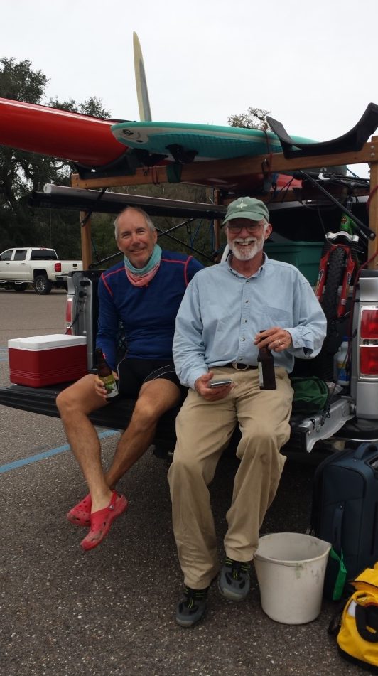
A roof, a stationary bed, plumbing and electricity. It’s a jarring change. I’d paddled an average of 55 miles every day, for 22 days with no days off. My sleeping brain continued the UF unaware it had ended. The incessant dreams of progress not made and checking to see the boat was still with me continued for weeks. I decided it was time for a cure. I asked DJ if she would like to come on a therapy trip and she jumped at the offer, tired of sleeping with a crazy person. We drove down to the Malabar area and launched 6 miles south of the BC38 spoil.

We had a great time checking out other spoils on the way, and setup camp in the afternoon. Perfect weather and the same perfect camp spot. I was fooling with my GPS and brought up my friends lot as a waypoint. I already knew it would say 86 miles, but the last time I stood on this spoil I had gotten in my boat and paddled that entire distance in one sitting. It was a pretty cool feeling, and it was behind me not ahead of me. We cooked a meal, had some wine, I slept like a baby and was done with the dreams.
When I think about the trip, it was wonderful to see DJ’s smiling face at the staging points. It was stressful for her chasing my butt around the state, gathering supplies, and dealing with not so sane Bob. I could not have done this without her. The fellow competitors, the encouraging FB posts and texts buoyed my spirits as well.
It was nice to have finished it. People ask did I ever think about dropping out? Not once. I was ready for it to be over half way through but there was always something new ahead. I once read a book titled “The Water In Between”. It’s a great sailing story and the title is the point. What you remember is the stuff between the start and the finish.
| “Always do what you are afraid to do”
Ralph Waldo Emerson |
“And it’s me who is my enemy Me who beats me up Me who makes the monsters Me who strips my confidence” Paula Cole |
“What could go wrong?”
“Clewless” aka Marvin Brager |